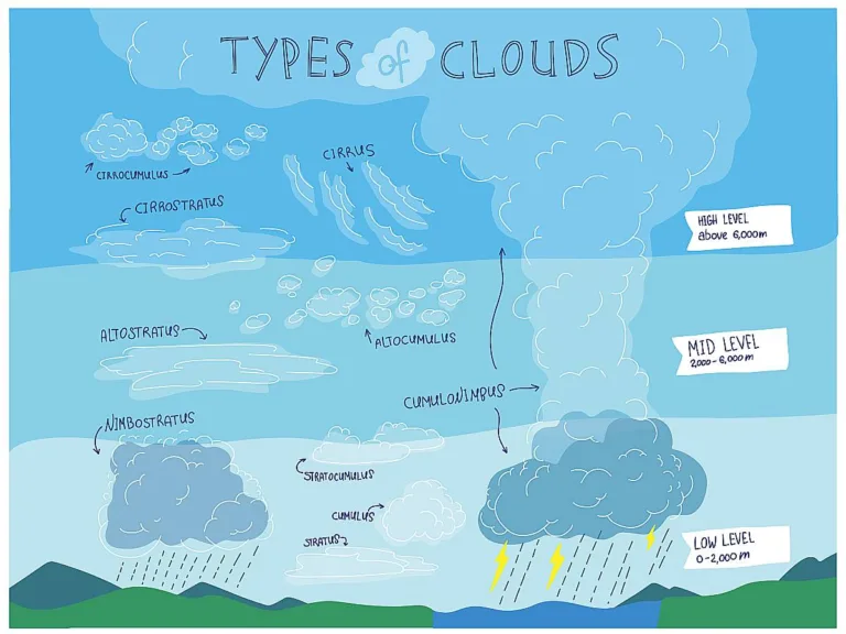
As you may have noticed, there are many different types of clouds.
Some are high up in the sky, thin, and wispy.
Others are large, puffier, and closer to the ground.
There are some clouds that are blankety, appearing to cover most — if not all — of the sky.
But what are the names of clouds?
And what do they mean for the weather?
I’ve been studying clouds since I was a kid, and I enjoy looking up at the sky and identifying clouds.
Here’s a rundown of the different types of clouds, along with photos of each kind and what these clouds can tell you about what’s happening with the weather.
Cumulus Clouds Explained
These are among the most recognizable types of clouds in the sky. Cumulus clouds look puffy at the top and their bases are flat.
Some cumulus clouds are small, while others are quite large.
Small, flattish cumulus clouds scattered across the sky usually mean fair weather.

In Latin, cumulus means “heap” or “pile.” And that’s how cumulus clouds tend to look — like heaps or piles of clouds.
Cumulus clouds sometimes grow like huge towers in the sky or form long rows. Their growth is typically convective and guided by thermals.
Usually, the larger and taller a cumulus cloud gets, the more unstable the atmosphere is.
As cumulus clouds grow taller and taller, they can begin to look like huge stalks of cauliflower.

These are known as cumulus congestus clouds and may indicate bad weather may soon begin brewing.

Cumulus clouds, like the one pictured above, are called cumulonimbus clouds. (Nimbus refers to precipitation in Latin.) They can brew some pretty serious storms, oftentimes leading to heavy rain or snow, lighting, hail, and even tornadoes.

Below is a picture of a supercell, or a very large cumulonimbus cloud that is capable of spawning serious weather such as high winds, hail, and tornadoes.

Cumulus clouds appear in many levels of the lower atmosphere, with the bases usually appearing at around 3,000 feet and up. The tops of cumulonimbus clouds can, in extreme cases, grow to a height of 75,000 feet!
If you ever see a cumulus cloud with an anvil top, watch out. That’s a sure sign of bad weather!
. They mean bad weather is brewing underneath. photo by districtinroadson Flickr")
Stratus Clouds Explained
Stratus clouds are the kind that stretch out across the sky.

In Latin, stratus means “stretched out,” which describes the typical form or habit of stratus clouds.
Unlike cumulus clouds, which tend to grow vertically, stratus clouds form in horizontal layers. These flat, hazy clouds range in color from dark gray to white.

Stratus clouds are generally low-level clouds, with bases oftentimes under 2,000 feet in height. In fact, fog is technically only differentiated from stratus clouds due to its low altitude. Essentially, fog is nothing more than a low-level stratus cloud.

Unlike their cumulus cloud counterparts, stratus clouds don’t bring thunderstorms or other violent weather. However, stratus clouds can mean light rain, drizzle, or light snow.

Cirrus Clouds Explained
Cirrus clouds are wispy, thin, and have the highest bases of the 3 major cloud types (high clouds, middle clouds, and lower clouds).

Cirrus, in Latin, refers to a curly lock of hair or ringlet. If you look at a cirrus cloud, you’ll see they look like flowing strands of hair.
In fact, the streamers that appear to blow away from cirrus clouds are often called “mares’ tails.”

These tails are actually bands of ice crystals.
The base of a cirrus cloud typically forms at around 18,000 to 20,000 feet or higher. Cirrus clouds don’t precipitate and, therefore, mean fair weather.

Other Types Of Clouds Explained
What we’ve talked about so far are 3 of the most basic types of clouds — those that form at the higher levels (cirrus), middle levels (cumulus and stratus), and lower levels (cumulus and stratus).
There are also hybrid clouds — those that have characteristics of 2 cloud types.
Here are some examples:
Cirrocumulus Clouds
Cirrocumulus clouds, which are small and ripply. These clouds are often dubbed “mackerel sky” and are 18,000 feet or higher. Cirrocumulus clouds are largely made of ice crystals, they don’t precipitate.

Cirrostratus Clouds
Cirrostratus clouds are high-level cirrus clouds that form a wide, thin layer — much like a typical blanket of stratus clouds. They are composed of very small ice crystals and do not lead to precipitation. For the most part, cirrostratus clouds indicate, with falling air pressure, dirty weather.

Altocumulus Clouds
Altocumulus clouds are rippled middle-level clouds in the 6,000- to 20,000-foot range that may bring light rain.

Altostratus Clouds
Altostratus clouds form a gray sheet in the middle levels of the lower atmosphere, around 6,000 to 20,000 feet up in the sky. Altostratus clouds can bring either rain or snow.

Nimbostratus Clouds
Nimbostratus clouds form closer to the ground as a sheet and are capable of producing heavier rain or snow.

Stratocumulus Clouds
Stratocumulus clouds form in the lower layers, usually 6,000 feet or lower, and take on a form of white rolls that can produce light drizzle.

Wall Clouds
Wall clouds sometimes form at the base of super cells and may foretell a tornado.

Shelf Clouds
Shelf clouds usually form on the advancing side of a thunderstorm. Shelf clouds often usher in the front wave of severe weather activity for an approaching storm.

Mammatus Clouds
Mammatus clouds form under the bases of thunderstorm in sinking air. They take on the appearance of sagging pouches. Mammatus clouds usually indicate that severe weather has passed and thunderstorms are weakening.

Lenticular Clouds
Lenticular clouds look like UFOs or spaceships, but actually are harmless (and rare) clouds that often take their unusual lens shape due to updrafts and winds around mountains. Sometimes, cap clouds can form at the top of very tall thunderheads. Lenticular clouds indicate instability in that layer of the atmosphere.

Undulatus Asperatus Clouds
Undulatus asperatus clouds are a recent discovery. Scientists believe they form in the wake of convective storms and, though appearing ominous, don’t usually bring stormy weather.

More About Cloud Types & Cloud Names
So the bottom line is…
There are 3 major types of clouds: high clouds, middle clouds, and lower clouds.
- Clouds that form at the higher levels are called cirrus clouds.
- Clouds that form in the middle levels are cumulus clouds and stratus clouds.
- Clouds that form at the lower levels are cumulus clouds and stratus clouds.
Beyond that, there are hybrid clouds that take on the characteristics of two separate cloud types.
In addition to the resources linked in the article, following are a few more sources regarding cloud types: