It’s hurricane season between June 1 and November 30.
As a Florida resident, I’ve grown up under the threat of hurricanes since I was born.
It’s just something I’ve grown accustomed to — perhaps much in the same way people from California become used to earthquakes, aftershocks, and other types of temblors.
Of course, hurricanes aren’t just a Florida thing.
They can strike anywhere along the Gulf Coast, Eastern Seaboard, and the Pacific Coast, too. Even inland areas experience hurricane conditions and tropical storm weather when these systems — some of them quite massive and powerful — barrel ashore.
If you live anywhere in or near a part of the United States affected by hurricanes, there are some changes you should know about this hurricane season that can help you and your loved ones better track and prepare for incoming tropical weather.
Hurricane season always brings a new list of storm names, but every now and then the National Hurricane Center (NHC) unveils other changes that can help people get ready for tropical storms and hurricanes more efficiently.
The NHC recently revised the way it monitors tropical weather, and these changes could affect when and how you plan for the storms.
Here’s a look at 5 new tropical weather forecasting changes you should know about during hurricane season:
#1 – Advisories will be made before storms form.
You’re going to hear a new term in the hurricane forecast during hurricane season. It’s a word that you may not be familiar with if you live anywhere close to the Atlantic: cyclone.
The term cyclone, which is more common when speaking about the Pacific and other parts of the world, is just another word for a storm system with winds that rotate inward to an area of low pressure, such as a tropical storm.
But the NHC will use the term cyclone from now on to warn people about a weather system that could pose a threat to land before it even actually turns into a tropical storm.
These will be called potential tropical cyclones and will be monitored as any tropical depression, tropical storm, or hurricane.
Why the change?
The goal is to get the word out as early as possible to people who are at risk of being in the path of a tropical storm or hurricane. By predicting the path and potential damage from a storm at this stage, coastal residents will have more time to make the proper preparations.
How this helps you
You’ll be able to prepare for the tropical weather potentially many hours earlier than before the new advisory protocol was implemented. This can give you more time to batten down the hatches, shop for emergency provisions, and evacuate if necessary.
#2 – The earliest arrival of tropical storm force winds will be forecast.
For years, weather forecasters were focused on predicting the position of the center of the storm, where the strongest winds are.
Nowadays, weather scientists are doing a better job at gauging the wind speeds throughout the entire wind field — the area of the storm where any and all strong winds will be found.
This makes it possible to tell residents when and where tropical storm-force winds will be experienced.
Why the change?
We don’t hear about tropical storm winds very much during hurricane season — at least not nearly as much as we do hurricane wind damage. However, tropical storm-force winds are very damaging and need to be taken seriously. Those who live in areas that may be affected by tropical storm-force winds, which measure 39 to 73 miles per hour in sustained force, need time to make necessary preparations for properly dealing with these strong winds.
How this helps you
Tropical storm winds can blow down small trees, break branches, blow yard furniture, and cause other havoc. By knowing the approximate time when you can expect the onset of tropical storm-force winds in your area, you will have a better idea of how much time you have to prepare for the severe weather before it hits your neck of the woods.
#3 – Storm surge watches & warnings will be issued.
Think of a hurricane and what comes to mind?… Wind?
If that’s what you said, you’re not alone. Many folks think of hurricanes and tropical storms as wind events. And they certainly are.
But tropical weather brings much more than just wind damage. It can also spell disaster for coastal regions and low-lying areas along the shore because of storm surge.
What is storm surge? In short, storm surge is an area of rising seas due to the lower air pressure changes and winds around a storm.
Why the change?
The lower a storm’s barometric pressure and higher the winds, the greater the storm surge — and the more damage that could occur in and around the areas of the storm’s landfall. So, scientists at the NHC have rightfully decided the amount of storm surge that may impact a region is critical to predict. Therefore, it’s including storm surge predictions along with the wind warnings we’ve been used to hearing about each hurricane season.
How this helps you
If you live anywhere along or near a coastal region, you will now have a better idea as to how strong the storm surge will be in your area and how much damage you might be able to expect. While you certainly can’t stop rising waters from sweeping onto your property, storm surge predictions can help you better determine how high the water might go, how much you’ll need to shore up your home, and — most importantly — whether or not you should be making early preparations to evacuate.
Obviously, if you’re in an area that local emergency management officials believe will be hard hit, you’ll probably be ordered to evacuate anyway. But that doesn’t necessarily mean you should wait for an evacuation order to leave. If you’re living on a street that you know is prone to storm surge flooding, or if your individual property is in a low spot, you might wish to evacuate sooner — especially if the storm surge warnings suggest your home will be affected by rising waters.
#4 – The cone of uncertainty will be smaller.
Better forecasting tools have allowed meteorologists to predict with greater accuracy where a storm will be several days out.
Since 2007, the 5-day cone of uncertainty — the geographical region where scientists believe the center of a storm will be 5 days into the forecasting future — is 35% smaller.
Why the change?
One of the overriding goals at the NHC is to improve tropical weather forecasts, and one way to do this is to provide better long-range accuracy in where a storm will likely hit. This can help mobilize storm preparations, launch more efficient evacuation orders, and ultimately save lives.
How this helps you
If you’re watching a TV tropical weather forecast or hurricane forecast and find your home inside the cone of uncertainty, you’re most likely (and rightfully so) nervous about the impact that the incoming storm may have on you, your loved ones, and your property.
It’s wise to be wary of tropical weather that may be heading your direction. But in most cases, the cone of uncertainty encompasses a lot of folks who will never receive more than a drizzle from the oncoming tropical storm or hurricane. Creating a smaller cone of uncertainty can do a better job of accurately predicting who might be within range of the storm’s center as the system makes landfall.
These more accurate storm forecasts potentially save lives, but the benefits don’t stop there. Reducing the size of the cone of uncertainty may also lessen complacency among the fortunate ones whose homes have been in the cone of uncertainty in past storms but experienced little, if anything, in the way of tropical weather during those events.
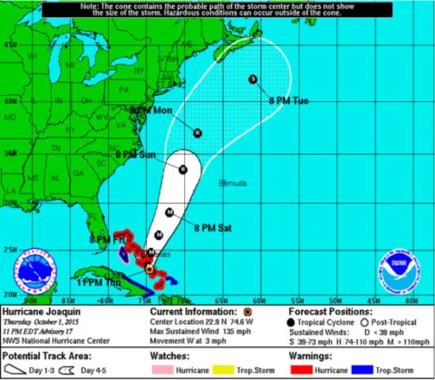
#5 – The weather advisory graphics will be better.
Who doesn’t like new and improved graphics?
The NHC is always trying to enhance its tropical weather forecasting products.
It’s doing so this year with a batch of changes that look flashier and will be easier for people to look at and understand.
Why the change?
There’s always a better way to present forecasting information to the public. This latest round of changes to the NHC tropical storm and hurricane forecast graphics makes the maps more colorful and easier for the average person to understand.
How this helps you
Ever scratch your head when looking at a forecast map on TV, online, or in the newspaper? The NHC knows a lot of people do, and they’re hoping to make it easier for you to understand their storm plots, storm path predictions, and storm system information this hurricane season.
Here’s a comparison of the 2015 and 2017 tropical weather forecasting graphics….
Out with the old:
And in with the new:
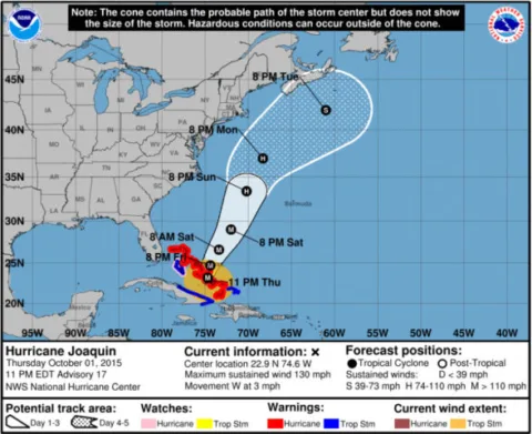
Pretty snazzy, huh?
More Information About Hurricane Season
In addition to the links I’ve included above, here are some other resources to help you better understand the current hurricane forecast and prepare for hurricane season:
- How Strong Is Hurricane Wind?
- Monitor Hurricanes With These Free Trackers
- How Hurricanes & Typhoons Form
- Hurricane Warning? 10 Things You Need To Do Now
- 5 Hurricane Categories & The Types Of Damage That Can Result
I'm a weather geek from Florida who's been studying meteorology and watching weather patterns for years! I enjoy sharing little-known facts and fun stuff about the weather. I especially like sharing interesting details about weather events and conditions that can affect you… and how to prepare for Mother Nature's ever-changing weather patterns.
