Have you ever looked at your local weather map and wondered what all those weather symbols mean?
Sometimes the weather map itself can be a bit challenging — knowing what all those weather symbols mean, for some of us, is like trying to read Greek hieroglyphics!
Weather people use these weather symbols to denote virtually everything there is to record about weather, including:
- Temperature
- Wind speed
- Wind direction
- Precipitation
Some weather symbols, like temperature, wind direction, and the type of precipitation you probably already know, especially when they are displayed on your local weather map in a newspaper or on TV.
But some other weather symbols on your local weather map may be just a bit more difficult to figure out unless you’ve got a good handle on weather 101.
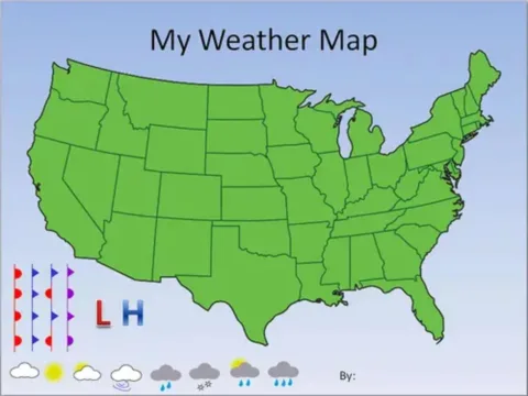
Here are 6 of the most-basic weather symbols you usually see on your local weather map:
- Blue line with small triangles: A cold front
- Red line with red semi-circles: A warm front
- Big line with blue triangles and red semi-circles: A stationary front
- Big purple line with purple triangles and purple semi-circles: An occluded front
- Big (usually blue) H: An area of high pressure
- Big (usually red) L : An area of low pressure


