Watching football on television today, I know that’s a question a few kickers are asking!
It’s simple, really.
Wind blows because of differences in air pressure or pressure gradient. The bigger the gradient, the stronger the wind.
Wind blows from high pressure to low pressure on the weather map, and turns right along the way because of something called the Coriolis Force (which we’ll talk about in another article).
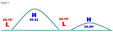
Looking at Figure 1, think of high pressure as a high hill. The higher the hill, the higher the pressure. If you were to pour a giant bucket of water on the top of the hill, it would run down hill to the valley at the bottom. The steeper the hill, the faster the water will run.
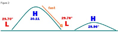
In the diagram, it’s easy to see that water will run more quickly from the hill representing 30.11″ High Pressure Area (Figure 2) than from the smaller hill representing 29.90″ (Figure 3).
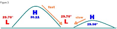
Wind follows the same basic rule. The steeper the pressure gradient, the faster the wind is going to blow.
Typically, if you are right in the middle of the high pressure area, you don’t experience much wind at all. Using the hill example again, the water poured onto the top of the hill hasn’t had a chance to pick up speed yet. But, on the side and on the bottom of the hill, that water is moving very quickly. It’s the same with the wind.
This, of course, is a very rough generalization, but the next time you hear your favorite television meteorologist talk about a strong pressure gradient, think about the steep hill and you’ll know what he’s talking about!
I’m a TV weatherman in south Texas. I get blamed for the bad weather, but I also get credit for the beautiful days. I absolutely love my job!